Click on any image to view them all in 'Lightbox' (TM)
For a quick search whilst on this page press Ctrl +F (Windows) or Alt+F (Mac) and enter the street/place you are looking for.
Duke street


The doorways and steps of 171-173 captured here by the LRO
in August 1993 can be seen as a full block on the pre war 2 page. Also here is
a 2010 view of part of the site of those steps.


Another LRO Aug 93 comparison with my own 2010 effort.
Sadly, the block seemed in a better condition back then that what it does today
apart from the more recent offering on the corner of Colquitt Street.


The block from Colquitt Street up towards Berry Street
(North side) is seen here when derelict in August 1993 (LRO). Gladly it has been
restored, rebuilt and extended to almost its original state and at least in
keeping with the conservation ropeworks area requirements as set out by English
Heritage.


The former Custom House pub on the corner of Campbell Street
(as seen on the pubs page). Here it is showing a former 'Mellors' sign (August
1993 - LRO) and can also be seen in its present guise on the streets ahead page
1.
Humyak House in Aug 93, although now a different paint job
adorns the frontage, it is gladly still in situ as is the fine Georgian
townhouse pictured next.


Dukes Terrace was Liverpool's last back to back housing.
Painstakenly dismantled and rebuilt, it now forms part of a three way block
with courtyard frontage and is fully occupied within a stones throw of the
bustling city centre.
Ayrton Saunders & Co. Ltd captured in August 1993. This
is on the South side of Duke Street towards Hanover Street.


Foggy Liverpool - William Brown Street to be exact on
saturday 6th Feb 2010.


Beech Street, Liverpool 7 runs as the continuation of Sheil
Road to Edge Lane. Some fine looking properties exist on this Street including
these at practically either end of it, Elm Terrace now being a derelict shell.


Beech Mount is on the opposite side of the street, the East
side and back on the West side is another fine terrace with an equally
impressive sweeping drive.


Derwent Road West in Liverpool 13 has a certain mix of
housing including this balconied property. The top of this Road leads to some
private land known as Derwent Square.


Derwent Square forks off to the left and to the right with a
patch of common grassland in between. Here, we see the properties bounding this
land.


The Pier Head in 1979 and St. Nicholas Place on the same day
as captured by Keith Rose.


Another 2 by Keith. Croxteth Hall Lane in 1979 with the now
demolished Dog and Gun on the right. Lastly, Roderick's chippy on Hebden
Parade, next to the pub - back in 1974.


If your name's Mary and you live here, then you're Mary from
the Dairy. First one is Attwood Street off Sleepers Hill and the second one is
Elm Road off Walton Village, both Liverpool 4.


Renfrew Street off Hall Lane, uniformly painted in blue and
white on glazed yellow brickwork making it very pleasing on the eye. These
cobbled streets are part of the Kensington Fields Conservation Area. First are
the uneven numbers on the North side of the street, then the opposite side is
viewed.


What we called the 39 steps, leading from Nethy to Prince
Rupert's Castle. Directly at the top of Everton Brow, the lock up became the
emblem for Everton Football Club, Ma Noblett's toffee shop stood on Browside
which runs up behind the smaller sandstone steps. Everton F.C. are of course
nicknamed 'The Toffees'.


Wavertree High Street displaying some of it's bygone era
architecture.


Buildings about to survive radical changes all around them.
Left: Durning Road, Right: Edge Lane.

Queens Drive at the Rocket Flyover, West side.

The Georgian Terracing on Shaw Street was lying dilapidated
during my youth in the 1970s as we'd often pass it. Since the 1990s, more and
more of it has been renovated, the blocks that were beyond repair, bulldozed
forever. The facade of this property is all that remains, I wonder what lies in
store for it. On the other side of William Henry Street, rubble is all that
remains here, pictured from Haigh Street.


Saint Bride Street in L8. Falkner Street garages and Burnham
& Gilroy Joiners and Bar fitters still trade. Only the cars tell you it's
2010.


Haven Road Fazakerley during a bout of snow in 1976, amazingly,
the year of that great summer. Also seen here in 1981 during the celebrations
that marked Prince Charles' marriage to Lady Di.


The Wellington pub on the corner of Islington and Christian
Street. Known locally as Cassons, it was on a Georgian row that was demolished
around 1971. Next we see Bunneys shop in the late 1950s on the city centre's
holy corner. It was somehow allowed to be demolished and a rather bland 60s
flat roof block stands there now housing Greenwoods. Both pics with thanks to
Colin Wilkinson.


Another fine area lost, captured here in 1964 is the corner
of Roe Street with St. Johns Lane. Next is Rice Lane on the block from Breeze
Hill/Queens Drive before the roundabout. Walton Village veers off to the left
and the tudor style pub near the traffic light is the Brown Cow. The tower of
Walton on the hill church on County Road can be seen in the distance. Pics with
thanks to Colin Wilkinson.


St Georges Place c1964 and c1965 respectively showing the
Guinness Clock curve in all its daytime glory, (for night time neons see above
and the home page)and also showing it during demolition to make way for St.
Johns precinct. With thanks to Colin Wilkinson.


Roe Street in 1969 with thanks to Lindsay Bridge and another
of Colin Wilkinson's showing the old St. Johns food market at Parker St and Gt
Charlotte Street in 1963.


County Road looking from town and then towards town as
captured by Keith Rose in 1973.


Barry Street off Walton Road for the Queen's Coronation in
1953. Colour photographs from the early 1950s are particularly rare. The next
one is the curve of Ranelagh Street into Lime Street captured in 1965. Both of
these are shared with us thanks again to Colin Wilkinson.
LIVERPOOL UNIVERSITY BROWNLOW HILL


Keys Court is the new arcade created by the knocking through
of the old Woolworths building on Church Street. Built on the site of St.
Peters Church, it takes its name from the crossed keys of St. Peter which stand
high up on the building. An about turn takes you to a child friendly grassed area
on School Lane.


The bottom of London Road complete with a Crawford's
biscuits delivery wagon, they were based on Binns Road. This shot was taken in
1960. Also seen is the Pier Head Landing Stage, or Lanney as we called it. This
is from 1966.


Fire Engines en route back to the fire station on Durning Road here in 1959 as taken by Ken para49.

Aladdin's Cave on West Derby Road.

Bowland Avenue, Childwall which runs into Bentham Drive on its way to Childwall Valley Road.

1960s Byrom Street towards the Queensway tunnel entrance and
around the same corner into the top end of Dale Street showing Unity House, HQ
of the Co-operative Insurance. Pictures by Colin Wilkinson.


Georgian Shaw Street with Cherry blossom trees and its park,
official name - Whitley Gardens. A place where I would go in the 1970s when the
Radcliffe Estate was new to its rear.


Croxteth Hall Lane has properties from different decades but
these are the oldest on the street.
A series of photos taken from the top of Marwood Tower on Great Homer Street in May 2010.


------------------------------------------------------------------


Dale Street in early May 2010 as one of Liverpool's oldest
Georgian shop blocks is rendered dangerous and has to be made safe.


By the middle of the month, the corner with Cheapside has to
come down revealing wooden beams that were last on show nearly 200 years ago as
this building dates back as far as c1819.


This warehouse with fancy balconies aside the hoisting
alcoves is on Atlantic Road in Bootle. The 'shaking hands' sculpture is
reminiscent of a tattoo my dad had on his forearm called 'Hands across the Sea'
to commemorates his Navy days and his comradeship with the Americans during
WWII. This appears to have been added to the building at a later date, possibly
from a Co-Operative building that was being demolished.


Houses on Carisbrook Road, Walton that have been given names
ending with 'Bank'. They are Moss bank, Fern bank, Finch bank, Willow bank,
Jasmine bank, Rose bank, Ivy bank, Oak bank, Holly bank and Beech bank.


The front, side and rear of the world's first prefabricated
residential housing implemented by John Alexander Brodie in 1904. They were
situated on Eldon Street, Vauxhall and are seen here in 1964 shortly before
their demolition. Thanks to Colin Wilkinson.


Next we see the former carriage works on St.Anne Street in
1975 with its fine wrought ironwork and glass frontage. As can be seen, it
later acted as a warehouse for Owen Owen but was sadly burnt to the ground in
the 1980s. The land stood derelict for quite some time before ironically, the
City fire station was built there to replace the one on Canning Place which was
demolished to make way for the Liverpool 1 Shopping centre.
Bottom right and the early morning (6am) sun rise in May
2010 as we approach North East along Dunnings Bridge Road, Netherton.


So I take a little walk to the Albert Dock area on Wednesday
2nd June in lovely warm sunshine then decide on the spur of the moment to take
the 'yellow boat cruise'.
En route to the ticket office, I pass this vessel in Canning
Dock and take a snap of the Atlantic Pavillion at the Albert Dock


My mode of transport for the next 40 minutes would be aboard
the Skylark boat as we'd tour the South docks system, or at least what's left
of it. The witty tour guide gave a live commentary. Live as in it wasn't a
pre-recorded tape like the Mersey Ferries, not live as in he wasn't dead.


It was strange seeing everything from such a low level. I
was used to looking down on these crafts from above. Now I was looking up and
across. An adventure in itself. I'm easily pleased you can see.


Heading out under 5 bridges from the Albert Dock into
Salthouse, then Wapping, then Queens then Brunswick, we were informed that by
law, every vessel has to blow its horn when passing under bridges so we'd hear
it 10 times in all on our trip. When this biggest cluster of Grade I listed
fireproof warehouses in the country were being renovated, it was decided to
include the 7 pillars seen here that are holding nothing up. That's because the
building above was bombed during WWII as these pillars act as a memorial to all
those dockers who lost their lives during the war as the docks being an
integral part in the war did not close for one single day during the war. The
renovation got underway as Tory, Michael Hesiltine pumped money into the
venture after the Toxteth riots in the summer of 1981. Before that, these mud
laden docks and dilapidated buildings had been earmarked for demolition for an
industrial estate. Now, it's one of the countries biggest attractions. The last
picture show the hydraulic pump which was disguised in an elaborate tower, one
of a few along the length of the docks.


The Baltic Fleet pub with it's funnel painted chimneys seen
from a position not often viewed. One of Liverpool's oldest pubs, it has its
own 'Wapping brewery' in the cellar. It was from here in another century that
poor victims would be press ganged into sailing the oceans. They would regain
consciousness while out at sea and with no possibility of returning home, would
be made to sign up to the ship they were on for 10 years. At this point we're
sailing South and passing lots of swanky new plush apartments and on the last
picture, the HQ of the H.M. Customs and Excise, built on what was Kings Dock.
Previously they had been situated in Cunard Buildings.


As we passed the rear of the Leo Casino, our guide mentioned
that we may want to take a photo of ourselves in the bevelled glass wall that
faced us. He wittily remarked that for those of us without camera, we may just
want to take the time to sit back and reflect for a minute. We were now
entering what on a day like today could easily pass for the French Riviera. The
apartments in view here sold for upwards of 650K and pleasure craft are moored
all along here.


It is reputed that Steven Gerrard has a boat moored here and
Tom Jones has one named after himself. The white one on the first pic, the
'Emmy B' registered in Liverpool is owned by Ex baby Spice, Emma Bunton.


Two other places of significant interest we passed were the
Liverpool Watersport Centre, kitted out with the finest equipment. I remember
when our only incarnation of such an activity centre for this was a little old
building on Athol Street that used canoes on the Liverpool/Leeds canal. The
other sight was of the rear of Liverpool's own Naval reserve base, HMS Eaglet.


Brunswick Dock's water levels are now constant but that
wasn't always the case when the River Mersey's tides dictated those levels.
This was a timber berth and when the tide was in, it was easy to unload the
cargo directly onto the quayside. However, when the tide was out, the water
level would drop some twenty feet so dock builder Jesse Hartley cut tunnels
into the dock wall to allow the heavy timbers to be unloaded to below street
level where horses and carts would back down a slight gradient to take their
cargoes. You can see where the tunnels have now been bricked up. We are now at
the River wall and in the last picture
shows a more recent man made sloping wall covering the gap where once
the dock met the Mersey. There is another gate to the right of this but as the
dock authorities charge £160 for exiting and entering it, this craft can't
afford to add that to its £5 ticket prices - thank God.


So with nowhere further South to go with the demise of
Toxteth, Harrington and Herculaneum Dock, we do an about turn and head back to
the Pier Head marvelling at our 21st Century surroundings that seemed a long
way away when as kids in the 1970s we would throw cobbles into the deep sludge
and watch them slowly sink. These pictures show the vertically laid and now
disused stone steps cut into the thick dock walls. As we head under another
bridge, we overtake the Duck Marine WWII landing craft which has taken tourists
on land to see Liverpool's civic buildings and Cathedrals before plunging nose
first into the dock.

More low level shots showing the arena, big wheel and Hilton
Hotel on the Strand from another perspective.


And so we re-enter the Albert Dock, sailing past the tugboat
'Brocklebank' at close quarters and getting splendid views of the new museum
nearing its completion and the three graces now partially hidden by the still
under construction black granite apartment blocks on Mann Island, since completed.
SOME COLOUR STILLS FROM THE MAGNIFICENT LIVERPOOL ON FILM 800TH BIRTHDAY CELEBRATIONS

William Brown Street with a bus stop slap bang outside the
museum when it was a major through road from the Queensway tunnel as seen on
the second still. The third shot shows the park and gardens keeper in St. Johns
gardens attracting the birds - of the feathered kind. A ribble bus can be seen
at the Old Haymarket terminus as well as Hesseys music store on Manchester
Street.


Hello, Hello, Hello. Is this you getting some directions
from a helpful police bobby at the rear of the Queensway tunnel. Henry Diaper
advertise their King Edward Street warehouses at New Quay next to the Queensway
Tunnel dock exit. Passengers disembark from the upper level of one of the
Mersey Ferries when they operated the two tier gangways.


Housing stills showing the Rokerby st/Field St area of
Everton off the Brow. Rooftops towards the Everton water tower and lastly a
rare colour photograph of one of the last courts.

Otterspool promenade, created from the Queensway Tunnel excavations and a train hurtles along the line at the rear of the Ford Car plant in Halewood.

Three views of St. Johns beacon under construction, the last
one including St. Johns Shopping precinct.
Three views of the Paradise Street area pre Liverpool 1. The Eagle pub, Moat House Hotel and BBC Radio Merseyside taking centre stage. Supplied by regular contributor Dave Duff.

Three views of the Paradise Street area pre Liverpool 1. The Eagle pub, Moat House Hotel and BBC Radio Merseyside taking centre stage. Supplied by regular contributor Dave Duff.

The Liver buildings from a different perspective as seen
from the dock exit of the Queensway Tunnel.
Another great fire engine scene by Andy Daley. Derwent
House, London Road is the place, the
Eros cinema is in shot too.


Tue Brook House, dating from 1615 according to its engraved
wooden door frame makes it one of Liverpool's oldest inhabited residences. It
is claimed to have a priest hiding hole from the time of the persecutions.
Opposite on West Derby Road is this fine row of cottages, one of which is
reputed to be haunted.


Two Stanleys - opposite each other on Prescot Road in the
olde district of Stanley between Fairfield and Old Swan. Here, we can see they
are just about complete with their original arches leading under the building
into rear courtyards.

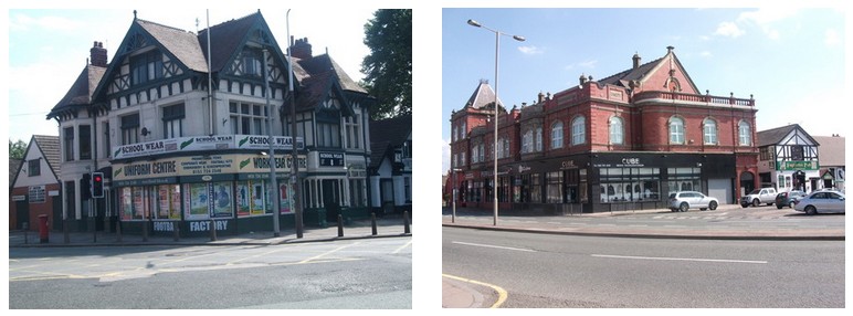
On Smithdown Road at Crawford Avenue near the railway bridge
is this fine building which currently houses a school uniform centre. A little
further along is Holyoakes Co-operative Unity building dating from 1914.


The ornate entrance gates to Wavertree Playground aka The
Mystery and just around the corner from them is Grant Avenue, L15. One side is
taken up with these impressive houses, the other side is the park itself.


Fallowfield Road and Earlsfield Road run from Smithdown Road
up to Prince Alfred Road, curving uphill near the end.


The demise of Kingston House and Coopers Emporium - a one
time hive of activity for weekend drinkers.


Another little piece of Georgian Liverpool. This time, away
from the city centre at Croxteth Hall Lane.

Four well known Liverpool landmarks.

Rumford House, Rumford Place which also has an alley leading
to a rear courtyard which is called
Rumford Court. This building flying the British and American flags has an
history dating back to the confederate issues in the states.
Prussia Street with one of its oldest buildings which are
gradually making way for new builds in the area.
The dock wall at Wapping still has still contains lopped and
capped Overhead railway stanchions along its length.


Bold Street in 1969 (Colin Wilkinson) All Pedestrians - please use the subway that once connected
William Brown Street to Gerard Gardens residents without having to cross the
busy Churchill Way flyovers.


The flyover motorways in the sky and the accompanying
elevated walkways became a way of life for us local residents in the 1970s and
80s.

Waterloo Dock warehouses are enjoying a new 21st century lease
of life as apartments. East Waterloo Dock itself is now surrounded by new
builds, designed sympathetically to fit in with their old surroundings. Here we
see views to the South towards the new riverside towers.


Hatton Garden - July 2010. A John Sutch Crane doing some work as the C3 to Canada Boulevard and the C1 to Queens Square head up.

The Liverpool to Leeds canal at Bridge Road, Litherland.
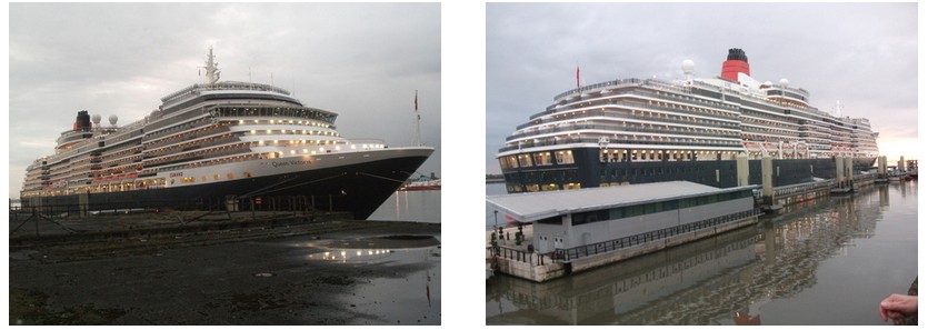
 |
| The ship at the cruise terminal and the Liver, just a few hours before she set sail. |
Entered Service December 2007
Country of Registry Great Britain
Speed 23.7 knots
Gross Tonnage 90,000 GRT
Guest Capacity 2,000
No. of Crew 1,003
Length 964.5 feet
Width 106 feet
Draft 26.2 feet

Regent Road aka The Dock Road, here at Brunswick Place showing an impressive warehouse. The street was once lined with these and the city centre end saw mass clearances of these in the 1960s and 70s. The next two shots were taken on Pacific Road, Bootle. Notice the holes in the walls which once housed huge beams that held the first floor.

Old property on Whitechapel nearing its end as firemen damp
down a blaze. Which boy didn't look in Frank Hessy's on Stanley Street or Curly
Music next door but one in the 1970s and 80s dreaming of owning that Les Paul
guitar.


The rear of Colliers, London Road as it's demolished during
August 2010. This was the place I was dragged to each August in the 1960s and
70s to be kitted out for my new school uniform. Then across the road to TJ's
for some other stuff, then up to London's shoe shop. Colliers had polished wood
drawers where the socks and underwear were kept, very Grace Brothers. They also
had that antiquated payment system where your money was put into tubes and sent
via a network of pipes to the upper floor offices where the transaction was
recorded and your change sent back down with your receipt. Another little piece
of London Road history bites the bullet.


The last residential housing on Cazneau Street finally is no
more. This once proud street housed a thriving school, paddy's market, a
numbers of pubs, a bank, tenements, flats and commercial premises as it made
its way up to Scotland Road from St. Anne Street. The Kingsway tunnel reducing
it to just a hundred yards long in 1971 was the beginning of the end but
perhaps we will see a rebirth of the area with new housing planned.


Hampstead Road leads East from Shiel Road down towards
Newsham Park. Some fine exterior colour schemes here set the houses apart. On
the journey along this road there are some pleasing terraces to be seen, not
least on Elm Vale and Balmoral Road with its unique angled corner properties.

Walton Lane properties between the railway bridge and Queens Drive. These are three storey houses including a basement. Church Road with its former 1930s council office. Walton Village at its corner with Heathcote Road showing the gable end date stone of AD 1905.

Sand stone in Walton: Anfield cemetery gates in Cherry Lane. Last used for the interment of one William Herbert Wallace. He was tried for the murder of his wife Julia in 1931. Found guilty and to hang, he was the first person to win an appeal on the grounds of the jury delivering the wrong verdict and so was reprieved. He lived only a further two years as an ailment caused by having only one kidney caught up with him. He was buried here in the same grave as his wife in 1933.
Walton Village is seen next at the rear of St.Mary's -
Walton on the hill church near the Queens Drive roundabout.

A collection of 1980s photos courtesy of local photographer Colin Tittle

The Airport control tower and two photographs of Garston Docks 1980s.

Two early 80s photographs of the Albert dock (above) and below some shots of the Pier Head


Anyone remember Beatle City on Seel Street ?

Back down to the Pier Head where in the first photothis old gentleman sits and watches the world go by, and then those angled bus bays followed by a shot of the gangway down to the pier that the kids all loved to cycle down

The Pier Head was always a great place for people to meet up for a gab and provided an inexpensive opportunity to see friends and put the world to rights. There was also the added bonus of being able to catch a convenient bus home to almost anywhere.

The old dock sheds adjacent to the former Riverside station

Another area that has undergone major changes, here Colin has captured the old Belfast Car Ferry terminal with Riverside station to the left of the photograph.

Two shots of the old Royal Iris one taken at the landing stage and another as she heads out across the Mersey. Sadly this old girl is now lying berthed and rotting away on the Thames.

Someones having fun ! a speedboat, photographed by Colin being put through its paces on the River Mersey.

a photograph of the Merseyside Police Headquarters taken in the 1980s, another landscape that has changed dramatically over the years.

In this final photograph in this set we see a new building nearing completion in Temple Street in the 1980s.
Inacity Living is grateful for Colins contribution to the site.
Index
St. Johns Precinct booming on a Saturday afternoon. Chruch
Street and The Big House, Lime Street likewise.
St. Johns Precinct booming on a Saturday afternoon. Chruch
Street and The Big House, Lime Street likewise.
A: Attwood Street, Atlantic Road, Albert Dock,
B: Beech Street, Barry Street, Brownlow Hill, Bowland
Avenue, Byrom Street, Brunswick Dock, Bold Street, Brunswick Place, Balmoral
Road,
C: Croxteth Hall Lane, Christian Street, County Road,
Carisbrook Road, Clayton Street, Cazneau Street, Church Road, Cherry Lane,
Church Street,
D: Duke Street, Dukes Terrace, Derwent Road West, Derwent
Square, Durning Road, Dale Street, Dunnings Bridge Road,
E: Elm Road, Edge Lane, Eldon Street, Earlsfield Road, Elm
Vale,
F: Fallowfield Road,
G: Grant Avenue, Garston Docks
H: High Street L15, Haven Road, Houghton Street, Hatton
Garden, Hampstead Road, Heathcote Road,
I: Islington,
K: Keys Court,
L: Lime Street, London Road,
N: Netherfield Road, New Quay,
P: Pier Head, Paradise Street, Parker Street, Prescot Road,
Prussia Street, Pacific Road,
Q: Queens Drive, Queens Dock,
R: Renfrew Street, Rice Lane, Roe Street, Ranelagh Street,
Rumford Place, Regent Road,
S: Shaw Street, St Bride Street, St Johns Lane, St Georges
Place, St Anne Street, Salthouse Dock, Strand Street, Stanley Street, St Johns
Precinct,
T: Temple Street
T: Temple Street
W: William Brown Street, Whitechapel, West Derby Road,
Wapping Dock, Waterloo Dock, Walton Village, Walton Lane,